
Friday, July 31, 2009


Thursday, July 30, 2009
July 29 & 30 High of 60 degrees in Estes Park, 103 degrees in Seattle?
It’s been a couple of lazy days here in the Colorado Rockies, very cool, overcast and occasionally rainy. But I’m not complaining, I could be in the Heat Capitol of the USA, Seattle Washington and sweating to the oldies with everyone else.
Today was tour day, we took the original road which crossed Rocky Mountain National Park, old Fall River Road, almost to Milner Summit. We crossed a 12,500 foot pass, and that altitude really makes you think about how much energy you choose to expend. A common theme in these pictures is “cloudy and cool”, please enjoy them in Seattle! Tomorrow we move on to Steamboat Springs and the weather forecast predicts it will be clear and temps into the 80’s. Sounds good to me!


Chasm Falls
 Kid on a rock

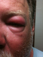
Facial contortions help the photo quality
 the Old Falls River Road
 check out the elevation, and we went higher after this


Today was tour day, we took the original road which crossed Rocky Mountain National Park, old Fall River Road, almost to Milner Summit. We crossed a 12,500 foot pass, and that altitude really makes you think about how much energy you choose to expend. A common theme in these pictures is “cloudy and cool”, please enjoy them in Seattle! Tomorrow we move on to Steamboat Springs and the weather forecast predicts it will be clear and temps into the 80’s. Sounds good to me!


Chasm Falls
 Kid on a rock
Facial contortions help the photo quality
 the Old Falls River Road
 check out the elevation, and we went higher after this


Wednesday, July 29, 2009
July 27 & 28 – Sunny in the mornings, monsoons in the afternoons, lightning overhead at night and a boy and his bike!
Mueller State Park in Colorado is probably the nicest state park that I’ve ever visited. It’s about 30 miles west of Colorado Springs, 5 miles south from Divide and Highway 24. The park is located at the very top of a hill/mountain and when we pulled into the park it was:
A) Raining like cats and dogs
B) The lightning storm was just beginning
Some might question the wisdom up driving to the top of a hill/mountain to pitch a tent with aluminum poles during a lightning storm, but not us. ‘course we did have to sit a bit for the rain to let up a bit to even pitch the tents, it was that coming down that hard.
The next morning was bright and beautiful, and I took off for a scenic trip through Cripple Creek, Victor and the Flourisant Fossil beds. Once again, a perfectly gorgeous day in the Colorado high country. Of course, the nice day couldn’t last forever, and as been the case for the past week, the rains came again in the late afternoon. Perfect time for a nap. The rains soon left, we did the normal campfire s’more junk and went to bed. Only to be awakened by the monsoons yet again, and a bonus round of lightning, directly overhead? I was doing the one thousand one, one thousand two, one thousand three counting thing, and to tell you the truth, I never got past one thousand four…And there were a couple times where I never even got to one thousand one…..
Alccording to the Wiki (and other independent sources) here is how to calculate how close the lightning is:
1. Watch the sky for a flash of lightning. Easy enough, could do it with our eyes closed
2. Count the number of seconds until you hear thunder.. Say "One one thousand, two one thousand etc." in your mind for each second. Got it, no problem, I can count to four
3. Divide the number of seconds by 5 to calculate the distance in miles (or divide by 3 for kilometers). In other words if you counted 18 seconds from when you saw the lightning, the strike was 3.6 miles (6 kilometers) from your location. The delay between when you see lightning and when you hear thunder occurs because sound travels much, much more slowly than light. Sound travels through air at about 1100-1200 feet (330-350 meters) per second (depending on altitude, relative humidity, pressure, etc.), which is a little more than one mile per five seconds (one kilometer per three seconds). In comparison, the speed of light is 983,571,058 feet (299,792,458 meters) per second.
Yup, it was directly overhead!
The next morning was just beautiful, clear and warm, we really took our time packing up and leaving the park, in fact the ranger pointed out that we were just about past the expected checkout time of noon. Our first stop was the Garden of the Gods Park in Colorado Springs, which really paled in comparison to the sights that we had seen earlier. Next planned stop was Golden Colorado, and somehow Josh and I (who was riding BOB on the motorcycle - Boy-On-Back) got separated from Matt and the Escalade. At least we had made plans to stop for lunch in Golden, so we knew what town to meet-up in. I didn’t see a single highway sign for Golden, so when I pulled off Highway 6 to check my map (in a very conveniently located County Coroner’s Office parking lot) someone asked me where I was looking for, and he looked very surprised when I replied “Golden”. He told me that I was already there and wanted to know exactly where in Golden I was looking for. Evidently coroners are particular like that. Beer and a Burger was a specific enough location for him and he directed us to a place downtown. Which, unfortunately looked dead as a doorknob. Coincidence for a recommendation from a coroner, I dunno, but it fits?
I make it a habit to avoid restaurants with no customers, and the place across the street had people drinking beer on their deck, so that’s where we headed. The name of the place was Woody’s Wood Fired Pizza and it was great. Shortly after we arrived we learned that that evening was the night for their monthly “Golden Cruise”, a one hour slow placed cruise through the town of Golden, that started in only 4 hours. After we hemmed and hawed, we finally decided to stay for the ride and got down to some serious pizza and beer. And Josh began plotting how he might win the grand prize in the raffle that evening , an XTC 8 Ball cruising bike. I won’t recap our many hours at Woody’s but Josh did have very positive Karma, and left with the bike he was lusting after.
We’re now in Estes Park, away from the dirt and mud, we have our very own hot-tub overlooking the river and it’s really, really nice. I like this WorldMark camping!
We’ll see what today day brings, besides a slight hangover!
Total cumulative miles – 6.970. I only planned on 7,500 miles for the whole trip, so it looks like I’ll run out of miles in northern Idaho
Best thing today – Josh was a winner
Challenge for the day – 4+ hours in a bar and remaining sober for the one hour ride to Estes Park afterwards. No way were we going to leave and go exploring and and come back, we’d give up our prime seats earned by arriving many hours early!
fuzzy artistic shot from Mueller State Park
 Cripple Creek, Colorado
 used to be something in Cripple Creek, I think!
 Petrified Redwood tree in Flourisant National Monument
 Isn't Colorado great, drive through liquor stores......
 Pikes Peak, I promise!

Not many bikes here yet for the "Golden Tour 2009"

A) Raining like cats and dogs
B) The lightning storm was just beginning
Some might question the wisdom up driving to the top of a hill/mountain to pitch a tent with aluminum poles during a lightning storm, but not us. ‘course we did have to sit a bit for the rain to let up a bit to even pitch the tents, it was that coming down that hard.
The next morning was bright and beautiful, and I took off for a scenic trip through Cripple Creek, Victor and the Flourisant Fossil beds. Once again, a perfectly gorgeous day in the Colorado high country. Of course, the nice day couldn’t last forever, and as been the case for the past week, the rains came again in the late afternoon. Perfect time for a nap. The rains soon left, we did the normal campfire s’more junk and went to bed. Only to be awakened by the monsoons yet again, and a bonus round of lightning, directly overhead? I was doing the one thousand one, one thousand two, one thousand three counting thing, and to tell you the truth, I never got past one thousand four…And there were a couple times where I never even got to one thousand one…..
Alccording to the Wiki (and other independent sources) here is how to calculate how close the lightning is:
1. Watch the sky for a flash of lightning. Easy enough, could do it with our eyes closed
2. Count the number of seconds until you hear thunder.. Say "One one thousand, two one thousand etc." in your mind for each second. Got it, no problem, I can count to four
3. Divide the number of seconds by 5 to calculate the distance in miles (or divide by 3 for kilometers). In other words if you counted 18 seconds from when you saw the lightning, the strike was 3.6 miles (6 kilometers) from your location. The delay between when you see lightning and when you hear thunder occurs because sound travels much, much more slowly than light. Sound travels through air at about 1100-1200 feet (330-350 meters) per second (depending on altitude, relative humidity, pressure, etc.), which is a little more than one mile per five seconds (one kilometer per three seconds). In comparison, the speed of light is 983,571,058 feet (299,792,458 meters) per second.
Yup, it was directly overhead!
The next morning was just beautiful, clear and warm, we really took our time packing up and leaving the park, in fact the ranger pointed out that we were just about past the expected checkout time of noon. Our first stop was the Garden of the Gods Park in Colorado Springs, which really paled in comparison to the sights that we had seen earlier. Next planned stop was Golden Colorado, and somehow Josh and I (who was riding BOB on the motorcycle - Boy-On-Back) got separated from Matt and the Escalade. At least we had made plans to stop for lunch in Golden, so we knew what town to meet-up in. I didn’t see a single highway sign for Golden, so when I pulled off Highway 6 to check my map (in a very conveniently located County Coroner’s Office parking lot) someone asked me where I was looking for, and he looked very surprised when I replied “Golden”. He told me that I was already there and wanted to know exactly where in Golden I was looking for. Evidently coroners are particular like that. Beer and a Burger was a specific enough location for him and he directed us to a place downtown. Which, unfortunately looked dead as a doorknob. Coincidence for a recommendation from a coroner, I dunno, but it fits?
I make it a habit to avoid restaurants with no customers, and the place across the street had people drinking beer on their deck, so that’s where we headed. The name of the place was Woody’s Wood Fired Pizza and it was great. Shortly after we arrived we learned that that evening was the night for their monthly “Golden Cruise”, a one hour slow placed cruise through the town of Golden, that started in only 4 hours. After we hemmed and hawed, we finally decided to stay for the ride and got down to some serious pizza and beer. And Josh began plotting how he might win the grand prize in the raffle that evening , an XTC 8 Ball cruising bike. I won’t recap our many hours at Woody’s but Josh did have very positive Karma, and left with the bike he was lusting after.
We’re now in Estes Park, away from the dirt and mud, we have our very own hot-tub overlooking the river and it’s really, really nice. I like this WorldMark camping!
We’ll see what today day brings, besides a slight hangover!
Total cumulative miles – 6.970. I only planned on 7,500 miles for the whole trip, so it looks like I’ll run out of miles in northern Idaho
Best thing today – Josh was a winner
Challenge for the day – 4+ hours in a bar and remaining sober for the one hour ride to Estes Park afterwards. No way were we going to leave and go exploring and and come back, we’d give up our prime seats earned by arriving many hours early!
fuzzy artistic shot from Mueller State Park
 Cripple Creek, Colorado
 used to be something in Cripple Creek, I think!
 Petrified Redwood tree in Flourisant National Monument
 Isn't Colorado great, drive through liquor stores......
 Pikes Peak, I promise!
Not many bikes here yet for the "Golden Tour 2009"

Not quite as interesting as Fremont in Seattle, but there were some contenders...

Matt, sitting at our prime seatage
 Josh preparing to make his investment in raffle tickets

One of these is not like the others. Can you find Waldo (Mark's motorcycle) in the picture?
We're getting ready for the big ride:
 I asked her first, I don't know why she looks so annoyed!
 One more, just because. She told me next time she'd charge me $10.

In front of the Coors Brewery

The object of Josh's lusting

The happy winners


Matt, sitting at our prime seatage
 Josh preparing to make his investment in raffle tickets
One of these is not like the others. Can you find Waldo (Mark's motorcycle) in the picture?

We're getting ready for the big ride:
 I asked her first, I don't know why she looks so annoyed!
 One more, just because. She told me next time she'd charge me $10.
In front of the Coors Brewery

The object of Josh's lusting

The happy winners

Yeah, really, I had the winning ticket!

You're mine now. I want you to know that and you need to please me often!
 Thanks Golden!


You're mine now. I want you to know that and you need to please me often!
 Thanks Golden!
new and improved with PICTURES
I'm back in the land of technology. I can do pictures again!
I've updated the posts from
July 21 & 22
and
July 23, 24, 25 & 26
with color photos!
I've updated the posts from
July 21 & 22
and
July 23, 24, 25 & 26
with color photos!
Tuesday, July 28, 2009


Monday, July 27, 2009
July 23, 24, 25& 26 AT&T has a lot fewer bars in a lot less places than they tell you
Chris diplaying his rodeo skills:
 The gunfight
 the hill the boys climbed up, Josh did it barefoot

advertising

Josh displaying his rodeo skills
 damn, this is a high pass!

the payoff to the boys at the end of the hike

the 4x4 "unimproved" road to the steep dunes

dunes at sunset
 just a monntain (before the big lightning storm that day)
 it's really, really raining and thundering
 the Colorado Gators

now how did you get this Winnebago here?

the UFO Landing zone:

more of the landing zone


 The gunfight
 the hill the boys climbed up, Josh did it barefoot
advertising

Josh displaying his rodeo skills
 damn, this is a high pass!
the payoff to the boys at the end of the hike

the 4x4 "unimproved" road to the steep dunes

dunes at sunset
 just a monntain (before the big lightning storm that day)
 it's really, really raining and thundering
 the Colorado Gators
now how did you get this Winnebago here?

the UFO Landing zone:

more of the landing zone


All right, maybe it is the remoteness of northern New Mexico and southern Colorado, but other phones using other carriers besides of AT&T have service which works just fine, so what’s up with the goobers at AT&T? And since I’m ranting – hey AT&T what’s up with sending me a text message at 2am in the morning telling me that I was using too freaking much bandwidth when I couldn’t send or retrieve email, use the interweb, or post any pictures.? Ohhh, sure you apologized later, but you dumdass’s if your service doesn’t work – quit complaining that I’m using too much data. Besides I bought the unlimited data plan that you charge me for each month – remember?
Our time in Red River was very relaxing. My nephews used their time to act like goofy young boys. We saw what had to be one of the cheesiest gunfights ever staged in history, watched Josh display his mechanical bull riding skills, and then went back to the condo where somehow the nephews got talked into hiking up to the snow making machine on the ski slope right outside our back door. The rules were few, just make it to the machine, climb the tower and jump up and down on the platform. $5 extra to pee of the platform. I shelled out $45 total.
The trip from Red River to the Sand Dunes NationaL Monument was pretty for about 25 miles, until we very, very abruptly left the mountains and reached the plains. It was a night and day difference between the plains and the mountains. Not too much of interest on the drive (almost 100 miles) outside of the picturesque little town San Luis, the oldest town in Colorado, and Fort Garland, an old fort and museum.
The sand dunes were great. Windy enough that every night when you went to bed you had to brush a vey fine layer of sand off your bedding. The campground was full by 1pm, so it’s a good thing that we got there early (by 9am, can you guess what time we left Red River that morning?). We attempted the ‘unimproved road’ to the steep sand dunes by mountain bike and soon learned why the road is marked as 4x4 only.
The 2nd day at the dunes I took a side trip to Gunnison, a nice round trip of about 400 miles. My original destination was the Black Canyon of the Gunnison, but between the lightening, the sheets of rain, once again I wussed out and came up short. I was soaked to the bone, even wearing my rain gear, and the amount of lightening I saw made what I experienced in New Mexico seem trivial. Thunder that lasted at least 30 seconds, seeing 3 lightening strikes his the ground almost simultaneously, and the sheer volume of rain was amazing. Highway 149 was beautiful, and crossing three 11,500foot tall mountain passes was a bit exciting.
The morning of Sunday July 26, we broke camp and headed north, for Mueller State Park, about thirty miles due east of Colorado Springs. The day broke very, very fair, with no visible clouds, and we had a nice stop at the Colorado Gator Farm, where they have over 300 alligators, some of which stay outside year ‘round! The farm is located on geothermal hot springs and was originally started at a tilapia fish farm and they just had the gators to take care of the entrails and such after the harvest. But it seems that there might be more money in exotic reptiles. I also stopped at the UFO landing station, which is a really, really hokey place with a funny alien garden, an odd observatory platform and a couple of (slightly eccentric?) owners. There wasn’t anyone about when I pulled up, buy soon enough an old lady in a golf cart came driving up ad asked me about my UFO observance history and when I explained that I had none, she proceeded to fill me in on hers. It seems that there had been reported UFO observances (and cattle mutilations she mentioned in a hushed voice) here in the valley since 1500, she had two vortexes to different dimensions in the alien garden and that she started this place in 1978. Funny coincidence, she had never had a UFO sighting herself until she opened this place. Hmmmm, marketing perhaps…………
And then the heavens opened up again and it rained. Never quite hard enough that I stopped to put on my rain gear, and there were occasional patches of blue. But overall, the last hour of the drive was pretty miserable. But the sun is now shining, the birds are singing and it’s just flat out beautiful here in the Colorado Rockies. Today 7/27 – Cripple Creek!
Subscribe to:
Posts (Atom)

